
McNary Gold Project, Arizona
Yavapai County, Arizona. Proposed Aquisition
1. Project Overview
McNary is an early-stage gold and base-metal exploration property in Yavapai County, Arizona, approximately 24.5 road miles southwest of Prescott. The current property consists of 31 unpatented mining claims covering approximately 633 acres, or 256 hectares. Historical records cited in the June 2026 technical report indicate approximately 1,600 ounces of gold production from the McNary workings. Seahawk’s interest remains subject to completion of the proposed acquisition, which is structured as a share-based transaction. No portion of the proceeds from Seahawk’s financing will be used to fund the acquisition.
Modern exploration has included underground mapping and sampling, 120 rock samples, 704 soil samples, approximately 60 line-kilometres of ground magnetic surveying and additional geological work. The results identify multiple gold and base-metal targets and support the interpretation of a possible copper-gold porphyry or breccia-related system. This work provides the foundation for McNary’s first modern drilling program. Seahawk is also advancing plans to expand the surrounding land position to a total area nearly three times the size of the current claim block. No mineral resource or mineral reserve has been estimated.
Ownership. The June 2026 technical report states that Sovereign Minerals Inc. holds a 100% legal and beneficial interest in the 31 McNary claims and identifies no other royalties, back-in payments or property encumbrances. Sovereign Minerals Inc. is a wholly owned subsidiary of Sunridge Gold Corp. Sunridge Mining Corp. holds an exclusive mineral properties operating agreement to operate, manage and develop the property. Seahawk’s interest remains subject to completion of the proposed acquisition.
Visuals: a clean regional locator map showing Prescott, the area currently recognized as Copper Basin and the McNary property. The map should clearly show McNary west of the currently recognized Copper Basin area without adding a fixed-distance interpretation.
2. Why McNary
McNary combines a reported history of gold production with extensive modern exploration, multiple gold and base-metal targets and a clear next major milestone.
Reported Historical Gold Production Historical records cited in the June 2026 technical report indicate approximately 1,600 ounces of gold production from the McNary workings.
Defined Land Position The current property consists of 31 unpatented mining claims covering approximately 633 acres, or 256 hectares.
Clean Ownership Structure The June 2026 technical report identifies no other royalties, back-in payments or property encumbrances. Seahawk’s interest is subject to completion of the proposed acquisition.
Extensive Modern Exploration Completed work includes 120 rock samples, 704 soil samples, approximately 60 line-kilometres of ground magnetic surveying and additional geological work.
Multiple Exploration Targets Gold, copper, lead and antimony anomalies have been identified across the property.
Three Mineralization Styles McNary contains quartz-tourmaline veining, gossanous breccia mineralization and fine quartz stockwork in rhyolite.
Potential Broader Copper-Gold System Metal-ratio patterns, a coincident magnetic low and broader gold and base-metal anomalies support the interpretation of a possible copper-gold porphyry or breccia-related system. Seahawk believes this system may extend westward beyond the currently recognized Copper Basin area and pass through McNary.
Planned Land Expansion Seahawk is advancing plans to expand the surrounding land position to a total area nearly three times the size of the current claim block.
First Modern Drilling Program McNary’s first modern drilling program is the project’s next major milestone.
3. McNary at a Glance
- Location: Yavapai County, Arizona, approximately 24.5 road miles southwest of Prescott.
- Land position: 31 unpatented claims; approximately 633 acres, or 256 hectares.
- Reported historical production: approximately 1,600 ounces of gold, as discussed in the June 2026 technical report.
- Modern work: 120 rock samples, 704 soil samples and approximately 60 line-kilometres of ground magnetics.
- Modern drilling: none completed to date.
- Resource status: no mineral resource or mineral reserve estimated.
- Current technical report: June 10, 2026, effective June 1, 2026.
- Land Position: 31 unpatented iode mining claims covering approximately 633 acres (256 hectares)
- Claim Expansion: 53 additional claims were recently staked. Subject to recording, the McNary land position would comprise approximately 84 claims covering 1,735 acres (702 hectares), nearly tripling its current footprint
- Future Expansion: Additional near-term claim expansion opportunities are under evaluation based on geological merit and land availability.
4. Reported Historical Gold Production
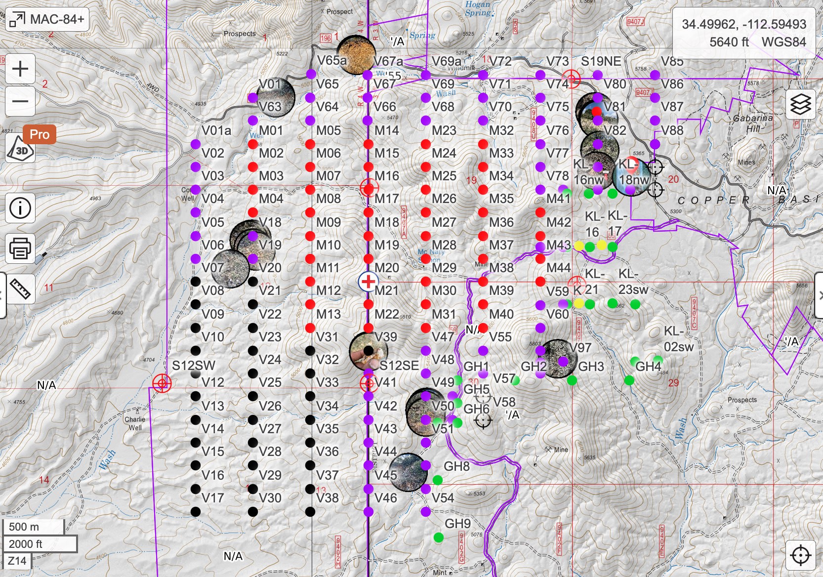
The June 2026 technical report cites historical records indicating approximately 1,600 ounces of gold production from the McNary workings, principally from gold-bearing quartz-tourmaline veins. This history of mining and gold recovery provides a strong foundation for Seahawk’s modern exploration of the broader McNary mineralized system.
The historic McNary Mine, also known as the Pioneer Gold Mine, was discovered around 1889 and worked into the 1930s, with selective underground mining of quartz-tourmaline vein material. The approximately 200-metre lower adit from that era has since been reopened, mapped and sampled as part of Seahawk’s modern exploration work.
Historical production information is derived from historical records, pre-dates current reporting standards and has not been verified. It is presented for historical context and is not indicative of mineral resources or mineral reserves. No mineral resource or mineral reserve has been estimated on the property.
5. Work Completed
Extensive Exploration Work Completed
McNary has undergone multiple phases of modern exploration. Completed work includes historical-record compilation, reopening and mapping of the approximately 200-metre lower adit, 51 measured-width underground chip samples, four principal phases of exploration between 2018 and 2023, and the collection of 120 rock samples and 704 soil samples.
Additional work includes approximately 60 line-kilometres of ground magnetic surveying, metal-ratio analysis and mapping, property-wide prospecting, geological mapping, imagery, terrain modelling and data verification. The sampling programs documented QA/QC procedures, and samples were processed by ALS Global, an independent geochemical laboratory. William Feyerabend, CPG 11047, also completed a field examination at McNary on April 18, 2026, during which 10 rock-chip and soil samples were collected. The June 2026 technical report concludes that the data are adequate for the report’s purposes and that McNary merits additional exploration. Together, this work provides the technical foundation for the property’s first modern drilling program.
Completed work at a glance
- Historic-record compilation and review
- Reopening and mapping of the approximately 200-metre lower adit
- Fifty-one measured-width underground chip samples
- Four principal phases of modern exploration between 2018 and 2023
- Collection and analysis of 120 rock samples and 704 soil samples
- Metal-ratio analysis and mapping, including antimony-to-arsenic and molybdenum-to-arsenic ratios
- Approximately 60 line-kilometres of ground magnetic surveying
- Property-wide prospecting, geological mapping, imagery and terrain modelling
- Independent sample analysis by ALS Global, documented QA/QC procedures, assay-certificate review and data verification
- Field examination by William Feyerabend, CPG 11047, on April 18, 2026, during which 10 rock-chip and soil samples were collected
6. Sampling Results
Reported Gold Results
Rock sampling completed in 2018 included 18 samples from the McNary vein and nearby outcrops, with three returning reported gold values between 17 and 42 g/t, together with elevated silver, copper and lead. Follow-up sampling in 2019 included 10 surface and underground samples, with three returning reported gold values between 15 and 38 g/t, also with elevated silver, copper and lead. The June 2026 technical report states that the quartz-tourmaline veins and micaceous breccia carried the highest values. In 2020, 31 rock-chip samples were collected from outcrops across the property, including three with reported gold values between 4 and 7 g/t and six between 0.1 and 1.0 g/t.
The December 2019 lower-adit program included 51 measured-width underground chip samples collected along the approximately 200-metre tunnel. These programs form part of the completed exploration work at McNary, which includes 120 rock samples and 704 soil samples. The complete results and sampling methods are summarized in the June 2026 technical report.
| Program | Sampling | Reported Gold Results |
|---|---|---|
| 2018 | 18 rock samples, McNary vein and nearby outcrops | Three samples between 17 and 42 g/t, with elevated silver, copper and lead |
| 2019 | 10 confirmatory surface and underground rock samples | Results summarized in the June 2026 technical report |
| December 2019 | 51 measured-width underground chip samples, approximately 200-metre lower adit | Results summarized in the June 2026 technical report |
| 2020 | 31 rock-chip samples from outcrops across the property | Three samples between 4 and 7 g/t; six samples between 0.1 and 1.0 g/t |
7. Expanded Geological Opportunity
Expanded Multi-Target Opportunity
The June 2026 technical report expands McNary’s exploration focus beyond the historic vein and the earlier gold-copper-tellurium corridor, which previous exploration identified over approximately 500 to 800 metres east-northeast from the historic workings. The current interpretation identifies multiple gold and base-metal anomalies, together with magnetic features that may reflect additional structural or intrusive complexity across the property.
The antimony-to-arsenic and molybdenum-to-arsenic ratio maps show contrasting geochemical patterns that appear to converge along a possible northwest-southeast structural break. Together with a coincident magnetic low and the broader gold and base-metal anomalies, these patterns support the interpretation of a possible copper-gold porphyry or breccia-related system.
The expanded target areas include:
- Anomalous gold mineralization identified by rock sampling away from the historic McNary vein.
- The largest and most continuous gold-in-soil anomaly identified in the report, located approximately 150 metres north of the historic vein and measuring approximately 250 by 150 metres.
- A broad, irregular antimony anomaly located over the historic McNary vein and extending southeast across several hundred metres.
- An eastern copper anomaly measuring approximately 600 by 400 metres.
- A lead anomaly within the eastern copper area measuring approximately 225 by 150 metres.
- A second broad copper anomaly northwest of the principal target area.
- A possible northwest-southeast structural break supported by a corresponding magnetic low.
- An approximately 500-metre-wide circular magnetic high northwest of the McNary vein that may represent an intrusive body, together with a separate donut-shaped magnetic anomaly immediately to the north.
Together, these features provide a broader framework for refining and prioritizing targets for McNary’s first modern drilling program.
These interpretations are based on surface geochemistry and geophysics. Subsurface continuity has not been tested. Modern drilling is intended to test these interpretations.
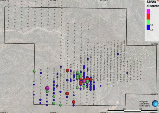
Plan view of antimony arsenic ratios
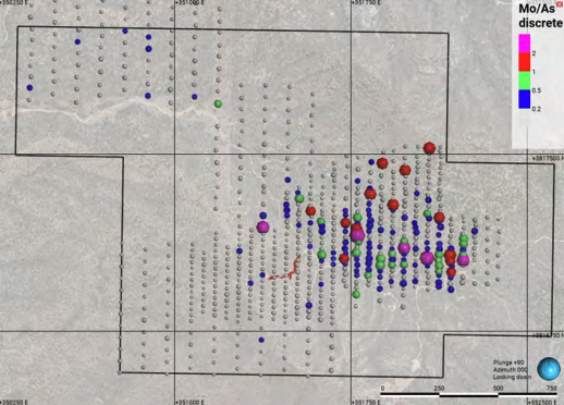
Plan view of Molybdenum/arsenic ratios
8. Mineralization and Deposit Models
Multiple Styles of Mineralization
Exploration at McNary has identified three distinct styles of mineralization: quartz-tourmaline veining associated with the historic workings, gossanous breccia mineralization in the eastern area and fine quartz stockwork in rhyolite north of the lower adit.
The June 2026 technical report considers an orogenic gold model, a copper porphyry or breccia model, and hydrothermal alteration associated with dikes. Under the copper porphyry or breccia model, the mapped Cretaceous tonalite and its border zone represent the possible metal source and targeted exploration area. The tonalite bodies mapped at McNary are interpreted to correlate with the approximately 73-million-year-old Copper Basin stock, while gossanous breccia mineralization in the eastern area occurs along or near the margin of the tonalite.
The report also notes that the historic quartz-tourmaline veins may have served as structural conduits for a younger mineralizing event. One exploration hypothesis is that the reported high-grade gold associated with the historic vein system may be related to a broader copper-gold porphyry or breccia system. The contrasting distribution of gold and antimony relative to copper, lead and zinc may indicate multiple mineralizing events. The property’s first modern drilling program is intended to test these possible relationships and further refine the geological model.
9. Copper Basin Geological Interpretation
McNary is located west of the area currently recognized as Copper Basin, a long-established mining district with documented copper and gold activity. The district includes copper-rich breccia and porphyry-related systems, volcanogenic massive-sulphide deposits and multiple gold occurrences. The June 2026 technical report notes that Cretaceous tonalite bodies mapped at McNary are interpreted to correlate with the approximately 73-million-year-old Copper Basin stock. At McNary, metal-ratio patterns, a coincident magnetic low and broader gold and base-metal anomalies support the interpretation of a possible copper-gold porphyry or breccia-related system.
Seahawk believes the geological formation and associated mineralized system may extend westward beyond the currently recognized Copper Basin area and pass through McNary. The property’s first modern drilling program is intended to test this interpretation. Seahawk is also advancing plans to expand its land position around McNary to nearly three times the size of the current 31-claim block, supporting a broader regional exploration strategy.
This is a geological interpretation to be tested by future exploration and modern drilling. It has not been confirmed. Information regarding the broader district does not indicate that similar mineralization exists on the McNary property.
10. Next Step: First Modern Drilling
First Modern Drilling Program
The exploration work completed at McNary provides the technical foundation for the property’s first modern drilling program. The program is intended to test priority targets, evaluate the possible copper-gold porphyry or breccia-related system and investigate whether the reported high-grade gold associated with the historic vein system is related to the broader mineralized system. The drilling method and final program design will be determined as exploration planning advances.
The drilling method, hole depths, orientations and total metreage will be determined as target refinement, access planning, permitting and logistical planning are completed.
The first modern drilling program is subject to completion of the proposed acquisition, financing, permitting and applicable agency authorizations. Timing is not assured.
11. Access, Permitting and Technical Disclosure
Access and Technical Disclosure
The McNary area is accessible from Prescott by a combination of paved and unpaved roads. Historic routes extend toward the former mine workings. Final access requirements for future exploration, including agency authorizations and any applicable bonding, will be addressed as part of final program planning.
The scientific and technical information on this page is based on the Technical Report on the McNary Property, Yavapai County, AZ, USA, dated June 10, 2026 and effective June 1, 2026, prepared for Seahawk Gold Corp. by William Feyerabend, Geologist, CPG 11047. Mr. Feyerabend is a Qualified Person as defined by NI 43-101 and is independent of Seahawk. The technical report is available here:
Seahawk’s interest in the McNary property is subject to completion of the proposed acquisition. See our full Disclaimer for forward-looking information and additional cautionary statements.